Read our 2023 annual report

Knowledge Hub
Missing Maps for Haiti: a volunteer project
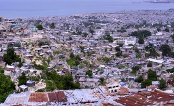
Many areas where Concern works are unmapped which makes implementing projects and preparing for disasters more difficult. In September 2016 we embarked on a new initiative to use volunteers to map basic information, such as buildings and roads, in Cité Soleil, Haiti. This is the story so far.
When is the last time you used a street map? It may have been to find directions while driving somewhere. Or maybe you used an app on your phone to find a café, or bus stop, or a taxi. Many large towns and cities around the world are now easily navigable via Google Maps and other online services – we almost take it for granted these days. But not all of them are, and this is where Missing Maps comes in. The Missing Maps project is using volunteers globally to fill the gaps in the network of world street maps, and recently Concern got involved in the project.
Mapping areas of humanitarian need
Open Street Map (OSM) is a free open software platform that uses satellite imagery and data to produce digital maps that are free to use. Missing Maps is a collaborative project in which anyone can use OSM to help map areas where humanitarian organisations are working. Missing Maps was set up by Humanitarian Open Street Maps (HOT) and other international NGOs who saw the benefit in volunteer-created digital maps for use in community projects, development programmes and emergency response situations. Find out how the Missing Maps project works.
Mapping Cité Soleil, Port-au-Prince, Haiti
So why are we mapping areas in Haiti? Concern has been working with communities in Haiti for over 20 years. In Port-au-Prince, our programmes aim to make sustainable improvements in poverty levels and mitigate against risks of conflict and disasters. While some areas of Cité Soleil in Port-au-Prince have been mapped, many areas are still missing basic information, such as buildings and roads, which makes planning and implementing projects more difficult.
Partnership with ESRI Ireland
In the summer of 2016, ESRI Ireland kindly offered to help us add details to the open source maps of the environments where our beneficiary communities live and work. Together we planned a series of Missing Maps events for Cité Soleil and we held our first event in the ESRI Ireland office on the 23 September.

Mapathon events are a popular way to map in groups and help each other learn the software, and Concern was happy to join up with more than 35 volunteer staff members at ESRI Ireland offices for our first mapathon session in September.
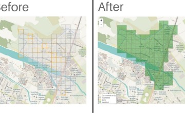
For our first session, our target area was Bois Neuf and Cité Gerard: densely populated neighbouring areas near the coast in Port-au-Prince. After an introduction to our Haiti programmes from Concern’s Laura Hastings, volunteers began mapping by carefully drawing around buildings and roads in Bois Neuf and Cité Gerard using drone imagery from 2014. To do this, we used the Missing Maps (HOT) task manager which is easy to use and looks like this.
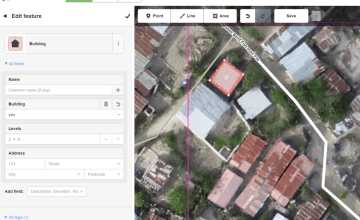
The team worked from a highlighting a grid of 106 tiles which covered the area to me mapped. By the time we stopped for lunch and to re-group we had mapped all the tiles once, so after lunch we validated the work already done and by the end of the day all tiles were green. We calculated we had added 1,448 buildings and 9km roads – a great result and a solid start at improving the digital maps.
Hurricane Matthew emergency
Since the September mapathon, Hurricane Matthew hit Haiti, causing great damage and leaving huge numbers of people in need humanitarian assistance. Concern is responding to the hurricane with distributions of household kits and reconstruction materials, and supporting communities to recover. More work is needed to prepare for future flooding and reduce the risk of diseases such as cholera for residents. New HOT tasks have been set up to support NGOs working in Haiti and the response from volunteers has been fantastic.
You can get involved
Anyone can contribute to Missing Maps projects by visiting MissingMaps.org and if you would like to get involved with the Concern project please email ellen.ward@concern.net or watch out for Twitter posts with the hashtag #MapCitéSoleil
